
The Proof is in the Plat Map: Your Neighborhood, Divided
- Published on
- 5 min read
-
 Sally Tunmer Contributing AuthorClose
 Sally Tunmer Contributing Author
Sally Tunmer is a writer and content strategist with 10 years professional experience focusing on real estate, travel and the lifestyle and culture of places. She was the former editor of the official New Orleans tourism blog and is a regular contributor to neighborhoods.com. Sally is currently based in Atlanta where she drinks wine, listens to music and writes about both on her personal blog.
At HomeLight, our vision is a world where every real estate transaction is simple, certain, and satisfying. Therefore, we promote strict editorial integrity in each of our posts.
Plat map: file under “things you would never know about unless you were buying a house, and maybe not even then.” A plat map is one of many documents in what seems like a deluge of paperwork a buyer encounters in the homebuying process.
If you’re wondering what on earth a plat map is and what it’s used for, you’re not alone. According to the National Association of Realtors®, a plat map is “a map, drawn to scale, showing the divisions of the piece of land” — that piece of land being where your home is located.
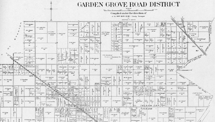
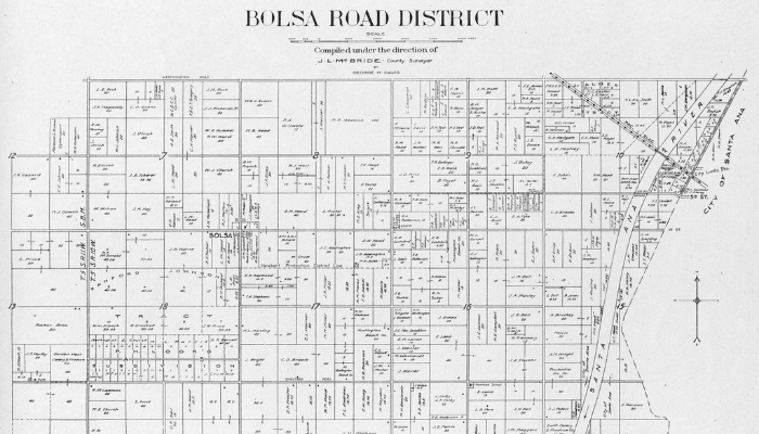
Plat, not to be confused with plot, shows more than the layout of a single property. If a plot is micro, then a plat is macro. It’s a parceled-out map of a defined area, like a neighborhood or subdivision. Essentially, a plat map is a bird’s-eye-view of your property and the surrounding area.
Typically, a plat map can be found somewhere in the pile of papers your title company presents to you at closing. It’s also something you or your agent can seek out ahead of time.
For those of us new to plat maps, which are probably all first-time homebuyers and even experienced homebuyers, what looks like a jumble of shapes and numbers can be hard to decipher.
Not to mention, you’ve surely had a site visit and walkthrough of your home before making an offer, unless purchasing it sight-unseen — not an uncommon practice during the pandemic. At this point, you know the location and have some sense of the area. So the question remains: What’s the purpose and benefit of a plat map?
Once you understand exactly what’s on a plat map and how to read one, it can offer a lot of useful information. We’ve done the research and talked to the experts to give you the critical insight on all things plat maps.

Plat maps: The what and the why
Let’s dig in further into what all a plat map shows and why it should matter to you, starting with a little history.
The origins of plat maps — also called cadastral maps, survey plats, or plat books — can be traced back to the 1850s as the first maps to document rural land ownership in the United States. Plat maps have evolved with the times, and it wasn’t until fairly recently that you could see a digital plat map.
The first plat map publisher was J.Q. Cummings, who founded Rockford Map Publishers in 1944. He meticulously researched and drew his plat maps by hand. Beginning in the early 21st century, with the help of Geographic Information System (GIS) mapping technology and computer software, plat maps were created digitally and eventually developed for smartphone and Google Earth compatibility.
Not all homes are platted. If the land around the house hasn’t been fully surveyed, or divided into different lots, then your house might not be found anywhere on a plat map until there’s more development around it.
What’s on a plat map and why it matters
A plat map outlines how your property is divided, the boundaries of the property, and all the surrounding property in the designated area, including other houses, residential land, streets, and any public land, like parks and playgrounds.
Sometimes, notes will accompany a plat map. The notes section can identify details like who is permitted to use certain tracts, who is responsible for maintaining public spaces, if there are any reserved areas for future development, and the locations of any protected trees or wetlands.
So, why is a plat map important? For starters, it provides an indisputable legal description of the property you own. Sellers don’t always list lot sizes and parameters accurately, so this is a valuable tool if there are any questions or discrepancies.
Furthermore, plat maps can confirm a lot of features and details about your future home-base, like trespassing lines, if the home is located in a flood zone, what direction each side of the house faces, any restricted areas of the property, and more.
These small details can have big implications. Some ways that analyzing the different components of a plat map could inform your purchasing and lifestyle decisions include:
- Ensuring the lot size listed by the seller matches what’s on the plat map — a.k.a. confirming you’re purchasing everything that’s legally yours and paying the right price for it. There are instances when a lot size is listed incorrectly, especially for oddly shaped lots.
- If you need flood insurance, and how to properly prepare for living in a flood zone
- If the house would be compatible with solar panel installations
- The available land space to build upon for a carriage house, shed, swimming pool, or another structure or outdoor feature
- Determining if a neighboring structure or fence encroaches on your property
If you are an investor or land developer, plat maps are super important. Plat maps are essential for developers interested in owning a large piece of land to build new construction property on, or who want to consolidate existing property.
Plat maps will dictate lot sizes and boundaries for subdivisions, show roadways, rights of way, common areas, and other important details to know when developing real estate. They are also used for larger-scale planning and zoning projects, like creating neighborhoods and incorporating official towns or cities.
Plat maps vs. property surveys: What’s the difference?
While plat maps and property surveys are very similar, they aren’t exactly the same thing. Plat maps show the legal property lines that belong to the owner, but they offer more of a big-picture view of an entire neighborhood or subdivision, whereas a survey is a more in-depth look of a single property. Typically, the title company will order a survey of the property at the request of the buyer.
Plat maps can indicate a need for a survey if there is any question about a structure or feature of a neighboring property extending past its boundaries, known as an encroachment.
“If we notice any encroachments — fence is off the line, shed’s off the line — we can approach the seller before settlement and have any issues resolved,” says Sue Smith, a real estate agent in Northern Virginia who completes 84% more sales than the average agent in her market.
“I don’t like surprises, and I don’t like my clients to be surprised. I believe the settlement is a time to be happy as opposed to a time when you negotiate your contract. It’s a time to sign your papers and get your keys,” says Smith. Reviewing the plat map and ordering a survey in advance of closing will ensure that smooth and joyful experience.
Easements shown on a plat map could also signal the need for a survey to get a closer look at an individual property.
According to the National Association of Home Builders, the definition of an easement is the “right-of-way granted to a person or company authorizing access to the owner’s land; for example, a utility company may be granted an easement to install pipes or wires. An owner may voluntarily grant an easement, or in some cases, be compelled to grant one by a local jurisdiction.”
Glennda Baker, a real estate agent in Smyrna, Georgia with 29 years’ experience specializing in single-family homes, illustrates just how much easements can affect property regulations.
A previous client of Baker’s was under contract for a home that had a sewer easement by the storm drain runoff on the right and back sides of the house, which is “very common.”
Because of her knowledge and familiarity with the local market, she knew because of a terrible flood that occurred in the area in 2009, her client would need a survey, “because these setback lines on these drains change if there’s been a flood,” and sure enough, the flood map had changed. By a lot.
She pressed her client, who did not want to spend $650 on the survey, and it was a good thing she did, because the survey revealed that the buffer on the storm drain had extended from 7 feet to 25 feet. This decreased the building area on the lot. That meant in a worst-case scenario, if something irreparable happened to the house (like it burned to the ground), they could not rebuild a house of the same size that would be anywhere close to the same value.
There are all kinds of easements that can run through a property and prevent the owner from building any kind of addition, like a pool, fence, or shed.
“That’s why you engage a professional real estate agent — because a professional real estate agent can give you a warning of the pitfalls of buying without a survey,” says Baker.
While plat maps are an excellent reference and legal proof of a property’s ownership boundaries, a survey takes verification a step further for added protection.
Where can you find plat maps?
There are three main entities that produce plat maps: the Bureau of Land Management, local government, and title companies. The Bureau of Land Management provides plat maps for federal lands. Those are available to search through in their digital archives and at the nearest federal land office.
Once a licensed surveyor creates a plat map for a residential area, it is recorded as public record. City and county records offices as well as online databases like Q Public will have these plat maps available to search.
Once under contract for a property, buyers will have direct access to the location’s plat map through the title company. The title company will deliver the plat map along with the rest of the documents from the title search.
For history, family tree and ancestry projects, historic plat maps can be found by looking through archives of the Bureau of Land Management, Library of Congress, and searching specific locations and time periods online.
Breaking down the plat map
We know that in general, a plat map shows the layout of a residential area, divided by the individual plots and public areas, but let’s get down to the nuts and bolts of it.
On a plat map, you can expect to find:
- The street names and the neighborhood or subdivision name will appear where applicable.
- The orientation will signify the placement of each property by cardinal direction, showing which sides of the house face north, south, east, and west.
- Plot details: Each plot will have an assigned parcel number, a lot number, a house number, and the measurements of the plot in square feet.
- Easements will show any parts of the plat area that the city or private companies have the rights to, meaning reserved areas that can be occupied or built on for specified purposes. These types of easements include:
- Utility easements include access for water, power, gas lines, phone, and internet.
- Access easements are reserved for certain roads and community trails.
- Native growth protection: This is an easement granted for the protection of vegetation within a critical area or its associated buffer. Its purpose is to preserve natural resources that benefit “public health, safety, and welfare” by controlling “surface water and erosion, maintenance of slope stability, visual and aural buffering, and protection of plant and animal habitat.”
- Greenbelts or open space: Greenbelt.org defines greenbelts as “undeveloped, wild, or agricultural land that surrounds urban areas.” Greenbelts can be any natural land, from wildlife habitats, wetlands, and recreational parks.
- Recreation areas: Trails, playgrounds, fields, and courts for sporting activities, parks
- Monuments: Monuments on a plat map are simply any boundary or point on a map, which is physically marked on the land itself by a surveyor.
- Roads: any roads or streets located within the defined plat area

How do you read a plat map?
So now we know what’s on a plat map, but how do you find all of these things? Let’s look at where each element is on the map and how it appears.
Keep in mind, all the plots — or each separate property unit — are represented by the individual square- or rectangle-shaped boxes on the map. Symbols and drawings will vary from one plat map to another, so always reference the legend.

To find the directional orientation of the plots, look for a prominent arrow-like figure, usually towards the top or the side of the map. This will show where north is, labeled with an “N” where the arrow is pointing, so you can tell which sides of the plot face north, south, east, and west.
The house number is located right outside the edge of the plot box at the street line.

The lot number is listed inside the plot box. The word “lot” will be listed with the number, or the legend will clarify which number inside the box is the lot number.
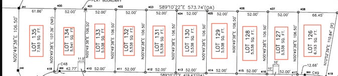
The parcel number is the other number listed inside each plot box that is not the lot number.
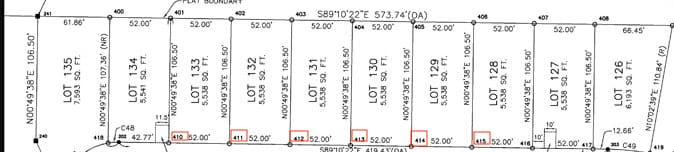
The plot dimensions can be calculated by looking at the numbers listed with a decimal or with the symbol for feet next to the number. These measurements appear around the plot’s edges, inside of the box. If multiple plots have the same dimensions, the number may be listed only once, meaning it’s consistent with the other plots.

Easements will be labeled along roads for access easements, within individual plots for drainage and utility easements, and anywhere else on the plat map indicated by the word “easement” and the corresponding type. Some easements, like sewer and utilities, will include the dimensions of the exact size.

The legend will indicate how to find monuments, which could be labeled with symbols like small solid black boxes or cross marks.

Recreation areas are labeled usually within a circular shape outside of the main residential area.

As you can see, what might seem like an insignificant document stuffed inside a folder from the title company holds a lot of pertinent information. While we all want to get to the closing table as quickly as possible, don’t sleep on your property’s plat map. It could be a crucial missing piece that shows exactly what you’re buying, which in some cases, might be different than what you thought.
Header Image Source: (Orange County Archives via Creative Commons Legal Code resized)
